
ViewRanger
Find hiking trails and bike rides, navigate with GPS, and save offline topo maps

ViewRanger is an Android application specifically designed for outdoor enthusiasts and hiking aficionados. It enables users to discover new trails, share their journeys with others, and access valuable content such as topographic maps.
Main Features
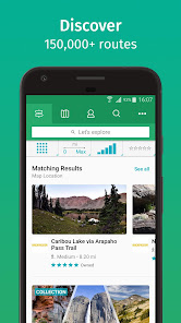
Upon launching ViewRanger, users are met with a wealth of routes shared by guides, tourism agencies, sports brands, and fellow community members. The application's intuitive interface ensures users can swiftly access these diverse pathways. Additionally, ViewRanger provides a platform for users to create and share their own guides, encouraging a vibrant, interactive community of outdoor enthusiasts.
One of ViewRanger's most innovative features is its time prediction tool. This functionality informs users how long it will take to reach the next checkpoint or the route's end. This can be of significant benefit when planning hikes and ensuring time is managed effectively.
GPS and Altitude Features
ViewRanger leverages the GPS on the user's device to provide useful information such as the altitude of a specific location. This data can provide valuable insights for hikers, particularly those traversing challenging terrains or high-altitude areas.
Route Recording
Perhaps the most engaging feature of ViewRanger is its capability to record users' routes. Users can track their journey on the map, accumulate statistics such as distance and altitude, and even add photos to their route. Once completed, these journeys can be shared with friends or the wider ViewRanger community, creating a digital chronicle of their outdoor adventures.
In conclusion, ViewRanger serves as a useful companion for any outdoor enthusiast. Its array of features – from route discovery to journey recording – make it a valuable tool for anyone looking to explore the great outdoors.
Pros
- Provides a wealth of shared routes for users to explore.
- Allows creation and sharing of personal hiking guides.
- Offers time predictions for reaching key points on the route.
- Leverages GPS for accurate location and altitude data.
- Enables route recording with added photos and statistics.
Cons
- The interface may be overwhelming for users new to hiking apps.
- Requires GPS to be enabled, which may drain battery life.


Goodbye from us. We have now switched off access to the ViewRanger app. Thank you to the global community of ViewRanger users who helped make our adventures so much fun.
We offer you an easy way to move to the Outdooractive app - where you can continue to access your maps, tracks, routes, POIs, and other ViewRanger app data.
Search for "Outdooractive" and download the app for free.
We'll see you in the Outdooractive community